
Just after the New Year, the Smith family went on a two-night backcountry trip to the High Chisos in Big Bend National Park. This was our first family desert trip, and it was a lot of fun.
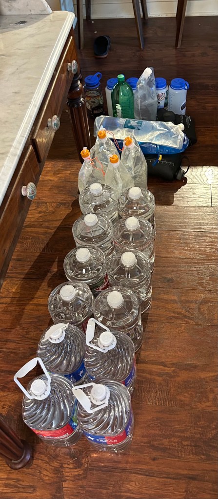
Most Big Bend backpacking trips are challenging because you must carry your own water. There are a few springs, but their flow is unreliable, and even when they flow, it takes a long time for a big group to fill bottles. With cool weather in the forecast, we carried 4L per person per day, which equaled 48L total. Collectively, this amounted to over 105 lbs of water! We are generally “lightweight” backpackers, but all our packs were heavy initially.
For food, we packed snacks for breakfast and lunch and carried two big cans of Mountain House freeze-dried meals for dinner. We slept in the big Oware pyramid tent, for which I made a Tyvek floor, and everyone had an air mattress and sleeping bag for expected temps in the low 30s.
I packed all the backpacks in the minivan the night before we left, and we rolled out of Austin at 4:30 am, heading west. After brunch in Fort Stockton (Rosita’s Café is not bad), we reached the park around 1 pm. The drive from the Persimmon Gap entrance to Panther Junction is always long, with the 40 mph park speed limit. We skipped the Visitor Center and headed right for the Chisos Basin. Rangers held us for a few minutes on the Basin road because there were too many cars and insufficient parking spots. We grabbed a parking spot opposite the convenience center, made last-second bathroom stops, loaded up, and hit the trail by 2:30.
Our first night’s campsite was LM (Laguna Meadows) 2. Although it was only a four-mile hike from the parking lot, it involved over 2,000 feet of climbing. The site included four bear boxes, which provided plenty of room for our food and water. We set up the tent, fired up the stove to boil water, ate dinner, and watched the rocks on Emory Peak change color as the sun lowered in the sky.

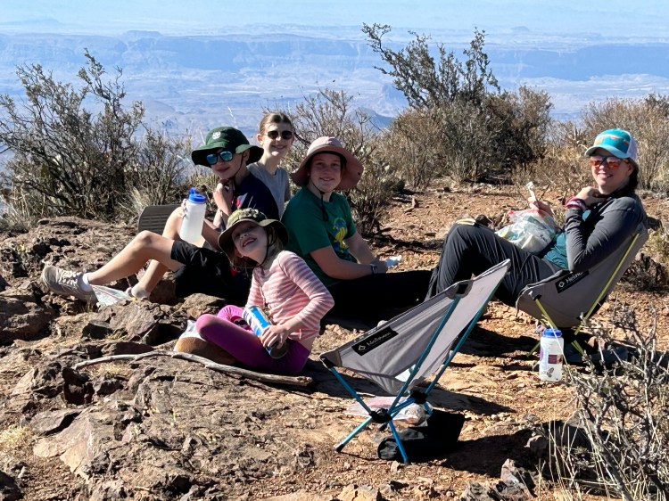
The following day was cool, and as we only had to hike a few miles, we had a lazy morning. Michelle and I enjoyed coffee and ate Mountain House Breakfast Skillet breakfast tacos. The hike to the South Rim was pleasant, and we saw a few deer.

Although I have been to the South Rim several times, each time, it is spectacular. We dropped our packs and had a long snack break at the South Rim overlook.
After the break, we walked about a mile to our campsite, ER (East Rim) 9. I initially chose this site because, on the map, it appeared close to a bathroom. However, my map did not reflect that the bathroom burned up in the 2021 South Rim fire. Since that time, anyone camping at a South Rim or East Rim backcountry site has been required to carry wag bags, and you have to haul out your poop. This was a slight complication, which we managed okay, but it is something to be aware of.
ER 9 is set back about 75 yards from the East Rim, and is relatively exposed because many of the trees there burned in the fire. It also has small tent pads, but we got the Pyramid set up and the camp established.

For the rest of the afternoon, we took a short hike without packs to the East, where we found a sheltered, shaded area to eat and play a few hands of Uno. About an hour before sunset, we grabbed dinner food and hiked about half a mile east, back toward the South Rim, where we set up on a promontory for a sunset dinner.
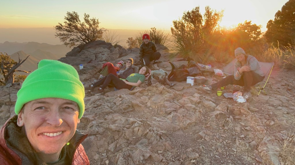
By the time the sun was down, the wind was picking up, and the temperature was dropping. Back at camp, we watched the stars come out – there is nothing like the West Texas sky – and turned in.
After a windy night, we got up early and were mainly packed to watch the sun come up.

We spent the morning hiking back north, got a good view of the Boot, and reached the top of the Pinnacles Trail by about 10 am.

From this point, a 1.5-mile trail heads up to Emory Peak. The NPS has placed a few large Bear Boxes here, and we stashed our packs and headed up. The wind was blowing, but it was a fun hike. The last 50 feet are a Class III rock scramble with some exposure. All four kids reached the summit, with tremendous views in every direction.

We climbed back down and high-tailed it back to the Pinnacles Trail junction, where we ate the rest of our food for lunch. From that point, it is about 4 miles down the Pinnacles Trail to the car. Those four miles always take longer than I think they should, but we made it down around 2 pm. I bought everyone an ice cream in the general store, and we piled in the minivan, heading for an Airbnb in Marathon, about 90 minutes away.
In Marathon, we had a nice dinner at the barbeque restaurant and chilled—literally—because the hot water at the Airbnb went out. The following day, we got up, rolled, and returned to Austin before 2.
Whenever we go to Big Bend, Michelle and I say, “We should come out here more often.” These short trips are great, low commitment, and something I want to do more of.
Planning Notes:
Suitability for Families – My 8-year-old did not have a problem but did not carry anything for most of the hike. My older three (12, 15, 17) carried their stuff and some group items easily. The biggest challenge is the water, which is just heavy. My pack included my stuff, my 8-year-old’s stuff, 18 liters of water, and some food. It weighed over 60 lbs at the start. Adults with backpacking experience who understand ultralight techniques should be fine doing this hike with kids. Taking kids on this trip with a traditional approach (heavy boots, heavy pack, heavy tent, bring a bunch of stuff) would probably not be very fun.
Campsites—All Chisos backpacking sites are reserved on recreation.gov and sell out for holidays. I booked ours in early October, when there was still good availability. You can book six months in advance.
Duration – I enjoyed taking two nights for this trip. We could have done it in one night, but the second day would have been long. It was nice not being in a rush, particularly with kids.
Route – From the Basin, hikers can choose between two trails to reach the South Rim: the Laguna Meadows Trail and the Pinnacles Trail. I prefer using Laguna Meadows for the outbound journey and Pinnacles for the return, as Laguna Meadows is less steep.
Chisos Basin Closure—The NPS plans to close the road into the Chisos Basin in May 2025 while rebuilding the restaurant. The project is scheduled to take two years, but a Ranger I spoke with was optimistic that access to the campground and trailheads may be restored earlier. Until the road reopens, the only ways to get to the South Rim are via the Blue Creek Trail or the Juniper Canyon Trail.
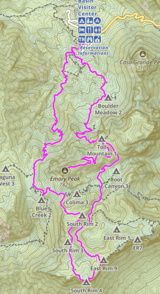
Map of Route

That’s for sure Gods country. Nothing better than a West Texas sunset to clear the mind. Someone mentioned to me th
LikeLike