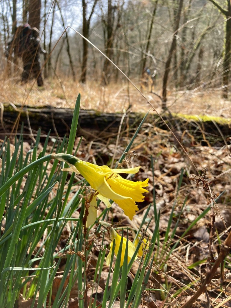
While watching my nephew’s YouTube report of his family’s vacation to a resort in the Bahamas my wife Michelle asked me “why don’t we do vacations like that?” I had to tell her it was because we only do Type II fun.
I did not come up with the fun classification system, but I love it. The system divides fun into three categories:
Type I Fun: Fun in the moment, not particularly memorable.
Type II Fun: Not very fun in the moment, very memorable.
Type III Fun: Fun in the moment, regrettably memorable.
Just about all the great fun is Type II fun, or at least Type I fun with some Type II spice. Occasionally, I like pure Type I fun, for instance a day at the beach. But if I am honest, I get bored with Type I fun in about two days. Hopefully, most of my Type III fun is behind me now that I go to bed by 10 pm.
Type II fun is the best because it is the most memorable, and the joy of the memories is worth the pain and frustration that comes in the moment of Type II fun. There needs to be some element of challenge or adventure or uncomfortableness to really have a great fun memory. A Type II fun adventure requires a plan that is a little (sometimes a lot) beyond the comfortable skill levels of the participants.
Tim and I deciding to canoe Barton Creek at 850 cfs when the only other people out there were kayakers with helmets. So we flipped and got worked. At least I did not lose my hat that day. Total Type II fun.
The key distinction between Type II fun and no fun is the word “almost.” Nobody likes an actual disaster. But an almost disaster is epic. Adventures involving bears, a raft full of camping gear going down a Class VI canyon, things catching on fire, marching through ice at 3 am on messed up legs – these are all great fun as long as everyone makes it home with life and limb. It can be a fine needle to thread.
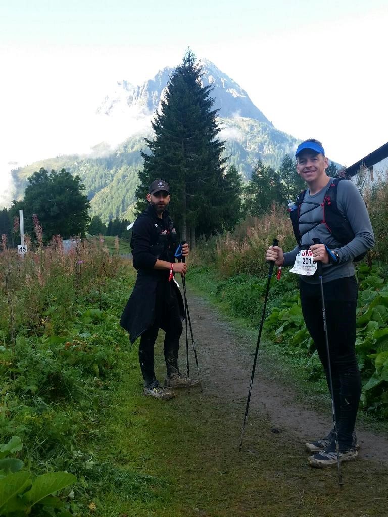
Type II fun at mile 88 of the UTMB. Doesn’t V look like he is having fun?
Type II fun also involves some element of work, of effort. This can be physical effort, like a long day of biking, mental effort like mile 82 of a 100 mile race, or spiritual effort, like not going insane on the 18th day of a road trip camping with four kids.
But great memories require great effort.
Little ones with packs and PFDs for adventure down the trail.
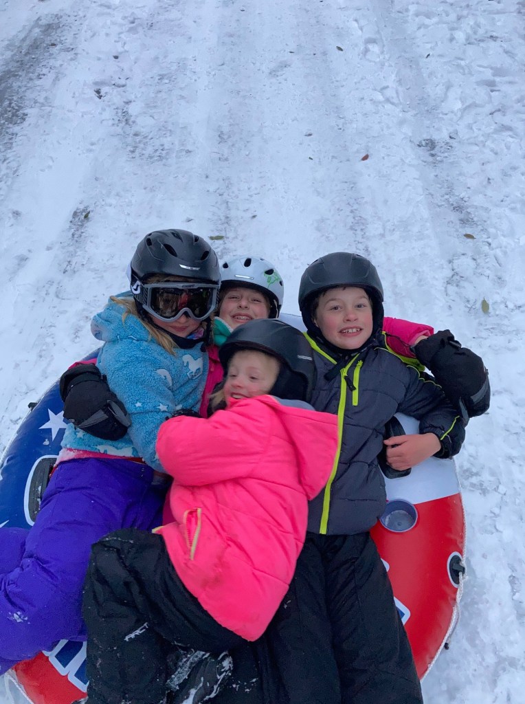
The most Type II fun of Type II fun has been introducing my kids to appreciate Type II fun. It is a work in progress, but they are coming along.
Anyway, bravo to all the tough ones out there going out and having some Type II fun.
In the age of watches that can play music, send messages, and do all sorts of other fancy things, I am a still big fan of the Timex Ironman Classic. The Timex has been around pretty much unchanged since the 1990s. It costs $35 dollars and is basically indestructible, small, light, and runs for years on a single battery. It just plain works.
Basically the same since I was in middle school.
What I like most about the Timex is its simplicity. It only does a few things, but it does those very well.
Its screen is easy to read in almost all light conditions and even with polarized glasses.
Its stopwatch function is very simple. One button gets you to the stopwatch then starting, stopping, and laps are controlled by two big buttons that are easy to hit swimming or running on a dark track.
It has a basic countdown timer.
It has alarms.
That’s it.
One of the trends in newer watches that I do not like is that they are huge and have sharp angles. This hurts function as huge watches get caught on clothes (taking off a layer) and the big faces can get damaged by things like Kettlebell workouts. The Timex is light and tiny and survives everything I have thrown at it.
Oddly enough, even though I own a GPS watch I find the Timex superior for some types of workouts. Specifically, track workouts and hill repeats. For these workouts I don’t need mid-workout pace data; I just need a stopwatch with a great lap function. The simplicity and big buttons of the Timex watch function works better than my GPS watch chronometer.
The other situation where the Timex holds its own is long runs or races, like ultramarathons, where I don’t need or don’t want my live pace but where the overall time is vital. For these I always have my phone anyway. The phone records my track just as good as a GPS watch, has far superior navigation tools, has a bigger battery and is easier to recharge mid race. The GPS watch is superfluous to the phone and is less reliable than the Timex.
There are some circumstances where I don’t pick the Timex. If I want to record my track but I am not taking my phone, I leave the Timex at home and take the GPS watch. If I am doing a workout that requires live feedback on pace or distance – like a tempo run – I take the GPS watch. Finally, if I am running a mountain ultra or doing a big backpacking trip in the mountains, I sometimes leave the Timex at home in favor of a non-GPS watch that has a long battery life but also an altimeter and barometer as knowing real time elevation in the mountains is useful.
Obviously, GPS watches are amazing inventions, and they have their place. If you like yours, great. But with complexity comes downsides. Maybe I am a Luddite, but I like my Timex for what it avoids: a mental distraction of always checking miles, wondering whether I have enough battery life to complete a run, frustration when the battery runs out or when the GPS data is not very accurate or it can’t find satellites. I think I will keep mine for at least a few more decades.
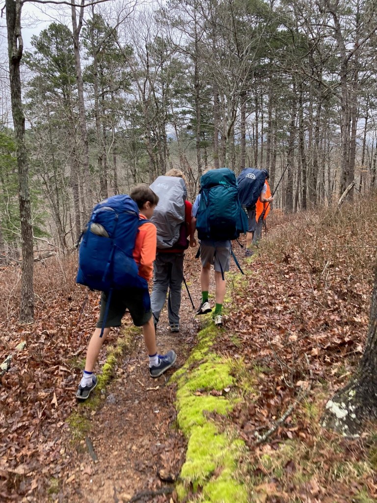
Arkansas is a strong contender on the all-underrated states list. Over spring break, I was reminded about just how underrated and how close – in Texas distances – it is to home. Austin Cub Scout Pack 14 took 13 scouts and 12 parents on a two-night backpacking trip on the Little Missouri River Trail in the Ouachita National Forest. For all the boys and many of the adults, this was their first multiday backcountry trip.
At the top of the only climb on the trail.
Given the inherent complications of planning a trip in Texas due to limited public land and the need to be Johnny-on-the-spot to grab reservations months in advance for most destinations – the trip to Arkansas was refreshing. No crowds, no permits, clear streams, and miles of spectacular trail.
The Ouachita National Forest in western Arkansas and encompasses the ancient Ouachita Mountains and the largest stand of virgin forest in the lower 48. Outside of developed campgrounds, camping and hiking are free and require no reservations or permits. While there are hundreds of miles of trail in the Ouachitas, I was looking for something moderately challenging that a group of 11-year-old boys could complete camping two nights and carrying their own gear. The Little Missouri Trail fit the bill as it is relatively flat, has plenty of bail-out options, and includes its own entertainment in the form of a spectacular clear river.
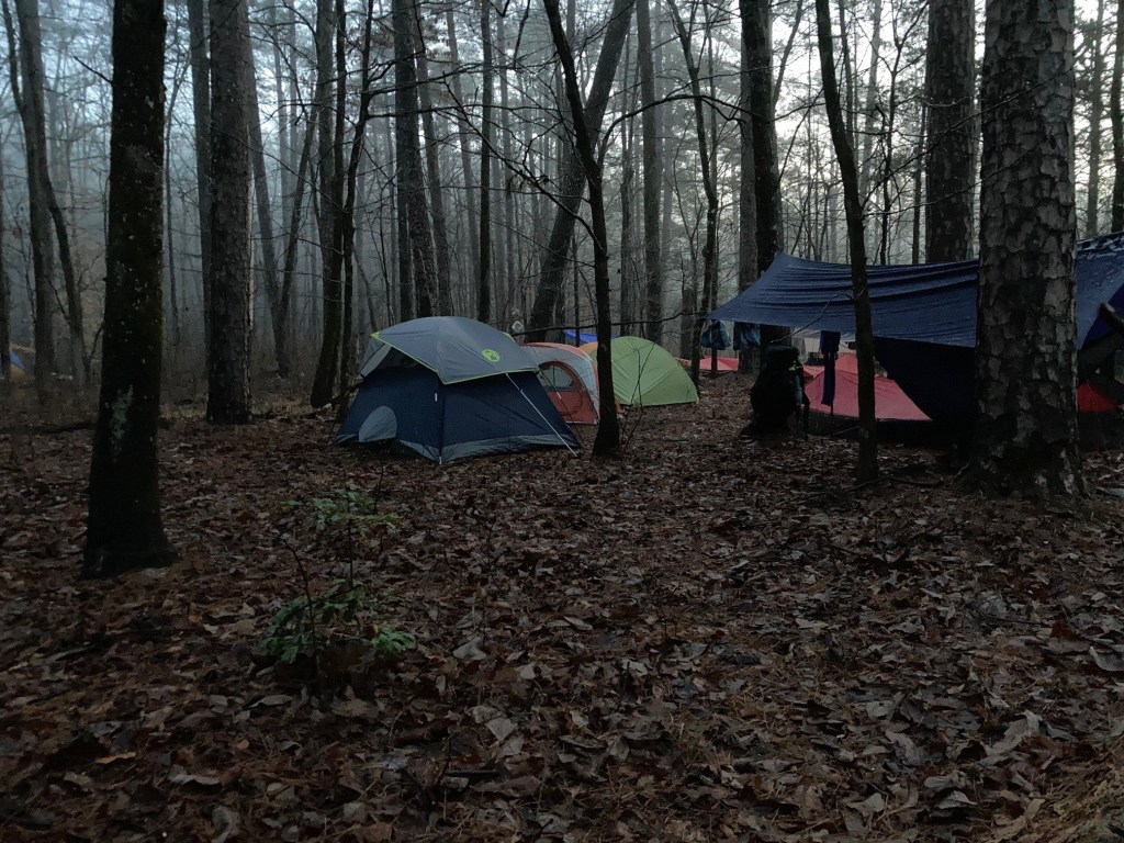
First night camp in the morning fog.
The Ouachitas are about 7 hours from Austin, so comparable in driving time to a trip to Big Bend, Palo Duron Canyon, or the Guadalupe Mountains. Unlike those destinations where hikers must carry lots of water, water and shade are abundant and a single water bottle is sufficient.
River Crossings, Flood Risk and Alternatives – In June 2010, a flash flood on the Little Missouri killed 20 people camping in the Albert Pike campground, including many who were trapped inside their tents at night. Anyone considering an overnight trip near the river should consider the risk of flash floods, monitor the weather, and select campsites accordingly.
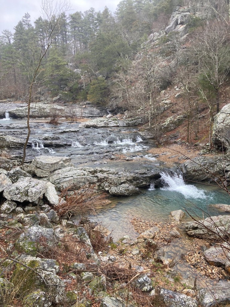
One of the many side streams.
Hiking the Little Missouri River Trail requires fording the river many times and crossing large tributary streams. Many have reported that if the USGS Gauge at Langley is less than 4.0 feet, the river crossings are safe. We found this to be accurate. During our trip, the gauge ranged from 3.5 to 3.8 feet and the river crossings were easy for adults and manageable for 11-year-old boys with packs.
The Little Missouri River
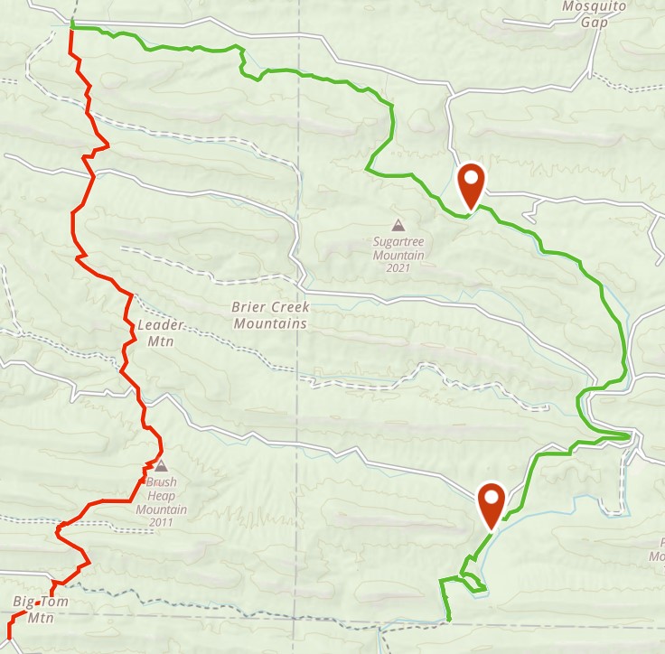
If planning a trip in the spring when thunderstorms are common, it is worth considering alternatives in case the river rises suddenly. For our trip, I had mapped out an alternate route on the Athens Big Fork Trail that we would have hiked had we deemed the river level unsafe. I also noted the locations of the forest service roads in the event we had to suddenly bail; most of the time reaching a road requires a bushwhack of ½ mile or less.
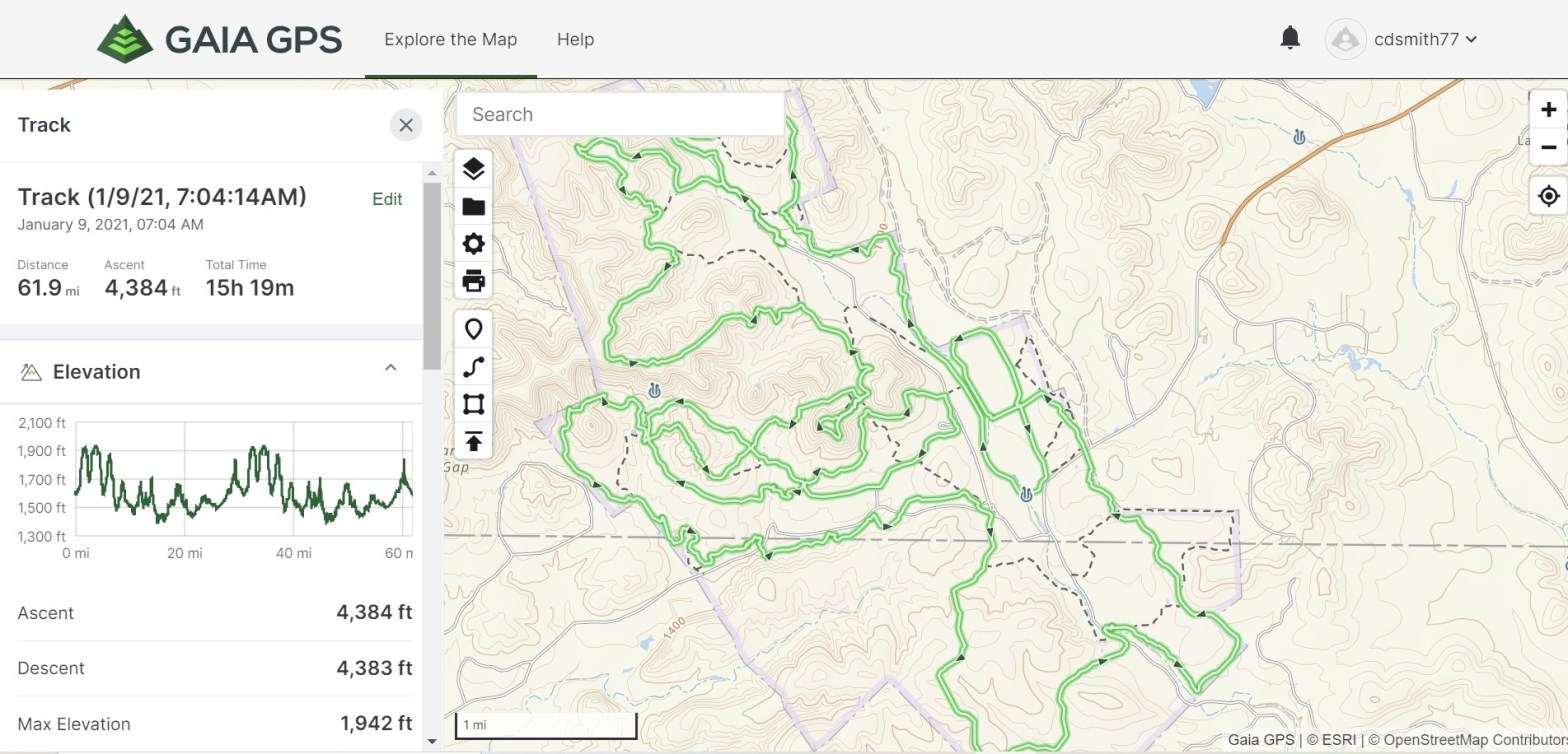
The Little Missouri River Trail (Green) with our two campsites identified. Our backup route is in red and avoids the river.
The Hike – For the most part, the trail closely follows the river. There is a hill of a couple hundred feet between Albert Pike and Winding Stairs with a great view, but otherwise its flat.
Elevation Profile
Campsites are informal and abundant.
Our second campsite near the Winding Stair trailhead. Plenty of room for a big group to spread out.
We walked through many old growth groves that, due to the ruggedness of the hills, avoided the axes of the last centuries.
This hike is great for beginning backpackers. Particularly if you hike with kids and a desert hike is not appealing, or you just want to get away from the crowds.
There are plenty of resources on lightweight backpacking for adults. But there is not much on outfitting kids, particularly late-elementary and middle school kids, for practical backpacking. As the den leader for a bunch of 5th grade Cub Scouts, this post explains the gear we have found to be useful for backpacking trips. Note that much of the gear is going to be more lightweight and minimal than traditional backpacking. Many of our scouts successfully used this equipment on a recent two-night backpacking trip in Arkansas, carrying 100% of their own gear.
Why Backpacking is Different for Kids
(1) For Kids Going Ultralight is a Necessity, not a Philosophy. While we all have different ideas about how much weight is “too much,” a starting point is the 20% rule which states that total pack weight should be less than 20% of body weight. For my 190-pounds, this equals a pack weight of 38 pounds which experience has taught me is pretty heavy for long days in rough terrain. My load-out weight for a five-night backcountry trip is usually 25-27 pounds. If anything, the 20% rule is pushing it for everything but short, mild trips.
Now apply the 20% rule to an 80-pound kid. That means total pack weight needs to be 16 pounds to be manageable and comfortable. Above that, there is a good chance that backpacking will stop being fun, and it needs to be FUN. Where “ultralight backpacking” is a philosophical point for many adults, particularly those with the stamina to suck it up and haul a heavy pack, it is a point of necessity for kids.
(2) Kids are hard on gear. A 5th grader will not appreciate the need to baby that dyneema composite shelter and may forget that the premium down sleeping bag needs to stay dry. He is going to set up camp and then start a game of tag with his friends. That means gear for kids needs to be simple, durable, and have a margin for user error.
(3) Kids bodies are growing. My decade-old pack fits the same as it did when I bought it. A 5th grader’s pack may not fit the same in six months. When shopping for kids’ gear, special consideration must be given to adjustability.
(4) Kids need affordable gear. Cost should not be a barrier for anyone wanting to get outdoors, particularly youth participating in scout programs. There is nothing wrong with a $300 ultralight tent, but I am not going to recommend that a young person needs to have one to get outside.
Specific Recommendations
Below I provide specific recommendations for the big-ticket items: packs, shelters, sleep systems, stoves, and water. I am sure there are many other products that work great, but these are the ones we have tested with 10- and 11- year olds. I have no affiliation with any of the companies below other than as a customer.
Pack: REI Tarn 40 Kids Pack ($100). This pack is great. It is a 40 L in internal frame pack weighing 2 lb. 10 oz. with an adjustable harness. The main compartment is top loading and hydration bladder-compatible, and it also has two hip belt pockets, two side mesh pockets, a large open topped back pocket, and a zippable top compartment. The main compartment is big enough to hold a synthetic sleeping bag, self-inflating pad, clothes, food, and stove. The back pocket is big enough to hold a light shelter.
My Scout with his REI Tarn 40. The back pocket is holding his shelter and a sweatshirt.
Unfortunately, it appears that REI may have discontinued the 40 L version and now only offers the 60 L version. The 40 L is far superior for smaller kids for a few reasons. First, the 60 L version has a listed weight of 4 lb. 5 oz; an increase of over 1.5 pounds in the pack weight alone. Second, and more importantly, the 60 L version is large enough that it encourages bringing more stuff than necessary, further increasing pack weight. On our den’s backpacking trip, every scout who hiked with the 60 L version had to have assistance from a parent at some point in carrying gear. Most 10- to 12-year-olds are going to have a hard time carrying 60 L of gear for anything over a couple of miles. Third, the 60 L version is significantly more expensive at $165. Once a pack is climbing north of the $150 price point there other, lighter options to consider. If the $100 40 L Tarn is not restocked, I would consider the following over any of REI’s kids packs:
ULA CDT ($145) – this is a 25 oz., 45 L top loading pack (size small). These packs are made in Utah. I have the larger version (the Catalyst) and its build quality and durability are outstanding.
Gossamer Gear G4-20 ($180) – this is a 25 oz., 42 L top loading pack (size small) and is time-tested lightweight pack.
Both the CDT and G4 are used by through hikers and have more than enough volume for a scout backpacking trip and are over 1.5 pounds lighter than anything REI offers.
Shelter:Oware Net Tarp 1 ($120). This is a 15 oz, 5×9 flat tarp with perimeter bug netting. There is no floor but the scouts use polycro or an emergency blanket as a groundsheet. Dave at Oware made our den a custom order in scarlet red. The only shelter option that keeps the weight close to a pound and the cost close to $100 are tarps. The perimeter netting is nice for Texas bugs.
Net Tarps pitched by 5th graders. There were no bugs here so some opted for an open lean-to pitch. Some are still working on the tauntline hitch.
The challenges of having kids use a tarp as a shelter are (1) the steeper learning curve on proper pitching and (2) the mainly psychological hurdle of camping in a shelter without an integrated floor. These challenges are not insignificant, however once a scout masters the tauntline hitch and can set up his net tarp by himself, he will have developed relatively advanced backpacking skills. It takes 10-15 field-realistic practices to learn tarp setup. One thing we noticed was that in a group setting all of the tarp lines can be a tripping hazard, and many scouts are replacing their lines with reflective glowline.
Net Tarp 1 pitched low, again all knots and stakes by an 11-year old.
If a tarp is simply not going to work or is not allowed (i.e., Philmont), there are other options, but they are significantly more expensive. I recommend the Tarptent Protrail ($229), which is a 25 oz. single wall tent with an integrated floor.
Sleep Pad:Thermarest Trail Scout ($55) This is 1 lb. 6 oz. self-inflating pad fits the sweet spot between cost, weight, compactness, and durability.
Sleeping Bag:REI Trailbreak 30 ($90) My son has slept warmly in this 2 lb. 8 oz. synthetic bag under a tarp in nighttime temps dipping into the 20s. There are many lighter, more compressible options, but those are all going to be twice as expensive.
Stove and Pot:Soto Amicus Stove Cookset Combo ($45) This gas canister stove comes with two pots; the kit is 11 oz but normally the little pot may be left at home.
Water Treatment:Lifestraw GoFilter 22 oz. ($40) Provided your trip has ample water sources, these bottles with incorporated filters are tough and easy to operate.
Scouts marching down the trail.
Scout Backpacking Checklist
Here is the checklist we used. With the recommended gear and adhering to this list (and not adding a bunch of other stuff) most of the boys were able to keep their packs right around the 16-18 pound range.
Backpack – < 3 lbs. and around 40 L capacity
One 18-gallon trash compactor bag to line backpack
Sleep Pad – < 1.5 lbs.
Sleeping Bag – < 3 lbs. and rated to at least 30° F
Shelter – < 2 lbs. and able to set up by scout
Water bottle and water treatment
Backpacking stove, pot, utensil, and fuel
Collapsible cup – for hot chocolate
Food stored in stuff sack or other bag
Bear/varmint hang: 50’ paracord and small carabiner
Personal first aid kit – (including moleskin for blisters)
Sunscreen
Bug Spray
Hand Sanitizer
Knife
Compass and Map
Whistle
Trekking Poles (optional)
Clothes in Pack
Raingear – this can be a poncho, rain jacket, rain pants depending on conditions
Insulating layer – fleece or light down jacket
Sleeping clothes – shorts or sweatpants and t shirt
Warm hat
Gloves (optional)
Camp shoes (optional)
Bandana
Clothes to Wear
Comfortable, broken in shoes (no Gortex because they do not drain)
Non-cotton socks
Hiking pants or shorts (synthetic, no cotton)
Synthetic t shirt
Sun hat
If you have other tips or questions on outfitting young scouts for the backcountry, please leave them in the comments.
With three kids in scouts, we spend a lot of time in the outdoors learning life skills through experience. One of the best things about the scouting method is that us parents are encouraged to let the scouts fail. Forget your sleeping bag once and you will remember it next time. This is learning to be prepared.
It’s not just the kids who learn that way.
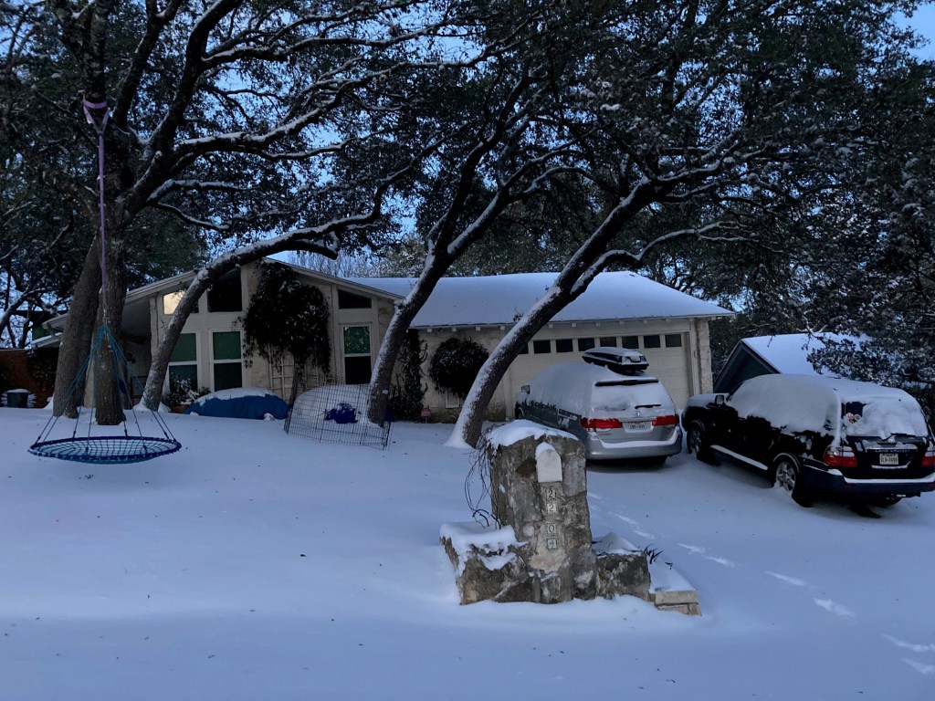
With a year of COVID and a now a Texas snowstorm, we have had the deficiencies in our preparedness pointed out. Maybe even rubbed in our noses. I have learned that a little “prepper” is not a bad thing. Consider:
We need more food on hand than we think we need. Last year before the pandemic really hit, I started getting worried and took a metal (i.e. rodent-proof) trash can in my garage and filled it with rice, pasta, beans, backpacker meals, and other dehydrated foods. There are enough calories in my emergency trash can to feed the six of us for a month. We also have about a month of canned goods stored. My wife stopped asking me to go with her to Costco because I would always get another huge bag of rice and more canned tuna. Fast forward to this week: We have no more fresh food in the house and the line to get in the grocery stores that are reopening is hours long. We are fine on spaghetti and canned peaches. But lots of people don’t have food. Once we get out of this, I may double our stored food supply.
We need an emergency water supply. After the power went down things froze up and pipes started bursting all over the city. It is slowly coming back, but everyone remains under a boil water notice. Many people have been without water for days and do not have fresh water to drink. We should all have a few days drinking water on hand along with a plan for more extended outages. Ours is to use our hot tub as a water supply. LifeStraw, Steripens, and other backpacking water treatment systems are a good thing to have around.
Pets are part of the family. Bob the leopard gecko warming by the fire while it is 10 degrees outside and 40 degrees in the house.
We need a plan for our homes to lose all services. How long could you live at your home with no electricity, water, and gas? This is important because in an emergency you may not be able to leave. Things to ask: Do I have enough lights and batteries? Warm clothes and sleeping bags? How will I cook food? Do we have enough propane or firewood? Can I shut off the power/gas/water to my house? What if the credit card payment system is down, do I have any cash? What will happen to the cell phone network if everyone loses WiFi? (Hint: it won’t work)
More snow that Austin sees in decades.
Have a plan and the means to leave if necessary. For most of us, most of the time, our homes are going to be the safest place to ride out a crisis. But that could change. Things like a reliable vehicle with good tires and a full gas tank make it a lot easier to get out of Dodge fast if you need to. Also, give some foresight to what you will take if you must leave in a hurry. When the house is on fire is not the time to think about where the photo album is stored.
Trust your judgment, not lying and incompetent politicians. How often do leaders head to Mexico when things get uncomfortable? Surprisingly often. I’m looking at you Cabo Steve and Cancun Ted. But seriously, who remembers just two weeks to flatten the curve? Or what about being warned to prepare for 40-minute rolling blackouts, only to then be told by your electric utility in the middle of the storm, just kidding we don’t even have the ability to implement rolling blackouts so your power will be off for days? These things happen. There is a whole realm of disasters that could last months and for which there is basically zero preparedness. Google the Carrington Event of 1859. To trust that the government is going to ensure your family’s safety is not a good plan.
Recognize that once everyone realizes there is a problem it’s too late to prepare. The time to get ready for bad times is during good times. If the infamous 2020 run on toilet paper taught us anything, it is this.
Have a plan to help others. While the best thing we can do is take care of our families, in any crisis there will be people who need help. In the Texas Snowpocalypse we had neighbors coming together to shut off water, dry out houses where pipes had burst, shelter those with no heat or water, and share supplies. Being part of a community is safer than being on our own.
The kids have thought this whole thing was a blast.
Do not despair. A scout is cheerful. A bad attitude in a crisis never helps. Despite the ever-present stress and uncertainty, focusing on thankfulness works. There are always fun memories to be made if we try hard enough.
Now I am going to the store to buy another trash can.
Most of us have been admonished at one time or another to focus on that which we can control. A year into the pandemic, we seem to have lost sight of this lesson. The narrative has focused almost exclusively on one element of risk control: limiting exposure to the virus through social distancing, masks, etc. But what about controlling the risk of developing a serious illness if we are exposed? What can we do and what role does personal accountability play? Perhaps quite a lot.
The greatest thing any of us can do to reduce the chance of developing a serious illness or dying if exposed to COVID-19 is to be healthy.
The CDC has data on cause of death for each person who died with COVID-19. (See Table 3 with data current through January 21, 2021). The CDC states: “For 6% of the deaths, COVID-19 was the only cause mentioned. For deaths with conditions or causes in addition to COVID-19, on average, there were 2.9 additional conditions or causes per death.” This means that about 19 of 20 people who die from COVID-19 die from COVID-19 plus some other condition and usually multiple other conditions.
The CDC has assembled a list of these underlying conditions and classified them based on the strength of the evidence supporting the link to severe COVID-19 illness:
Those with the “strongest and most consistent evidence” defined as consistent evidence from multiple small studies or a strong association from a large study.
Those with “mixed evidence” defined as multiple studies that reached different conclusion about risks associated with a condition.
Those with “limited evidence” defined as consistent evidence from a small number of studies.
Some of the conditions are uncontrollable; things like cancer and genetic conditions like sickle cell disease.
But many result from poor choices. The underlying conditions that have the strongest increased risk of severe illness include COPD (a lung disease preventable by not smoking), heart disease (preventable through diet and exercise), Type 2 diabetes (preventable by diet and exercise), obesity and severe obesity (preventable though diet), and smoking. Hypertension (preventable by diet, exercise, not smoking, reducing alcohol) is on the mixed evidence list and being overweight (BMI 25 and over) is on the limited evidence list. (Note: I acknowledge that in some rare cases some of these conditions may not be preventable, but for most they are)
These are not small problems. Take for example the issue of bodyweight. In 2018 9.6% of American adults were severely obese, 42.4% were obese, and 30.7% were overweight. Thus, over 80% of American adults have a preventable underlying condition that increases the risk of a severe illness from COVID, and which causes other conditions that also increase risk. And all we seem to talk about is masks and vaccines.
Maybe the reason the United States has one of the highest per capita COVID death rates in the world has less to do with shutdowns and masks and more to do with the fact that we have an already sick and vulnerable population.
Maybe the reason we hear nothing from our leaders about the importance of healthy living is that there are few corporate profits, no big government programs, and no bribery campaign contributions to be made. A chronically sick population needing hospital stays, expensive procedures, multiple specialists and a barrage of prescription drugs is so much more lucrative.
Maybe we should restart the conversation about health at the beginning, at the foundation and stop taking seriously anyone who claims to care about COVID but who avoids talking about the elephant in room.
It is certainly well past time for each of us, if we have not already done so, to do what is in our power to lead healthy lives.
As for me, I am heavier, slower, and weaker, than any time in the last five years, mainly because I have let COVID be an excuse to let it go a little. Time for some accountability. Time to clean it up, dial it in, and put in the work. COVID or no COVID.
Me at the YMCA today for first squats, presses, and deadlifts in a year.
For the past two years I have been using the Gaia GPS app on my iPhone for navigation and to record hikes and ultramarathons. I am neither a gadget nor app guy, but the utility of Gaia GPS is such that I felt compelled to write a review. Gaia GPS is the single most useful app for outdoor adventurers. (Disclaimer: I have no relationship with Gaia GPS other than as a customer).
What is Gaia GPS?
In a nutshell, Gaia GPS turns your phone into a GPS navigation unit that you can use without cell reception. If take your phone with you anyway on hikes and runs, as most of us do, it makes stand-alone GPS units obsolete and renders GPS watches unnecessary for many uses.
What is the cost?
While there is a free version, the basic $20 per year membership provides access to downloadable maps. This feature is key and is what allows for GPS navigation in the backcountry. The $40 premium membership provides additional specialty maps (backcountry skiiing, hunting, etc.), but I have found that the basic membership fits my needs perfectly. I have used the app on an iPhone 7 and iPhone SE.
Map Layers
The basic membership allows you to view either the Gaia Topo map, which is a simplified map, or a USGS Topo map. For sailors, the app also allows viewing on NOAA navigation maps. These maps are sufficient for everything I do. For those with additional needs, there are hundreds of other map layers to choose from.
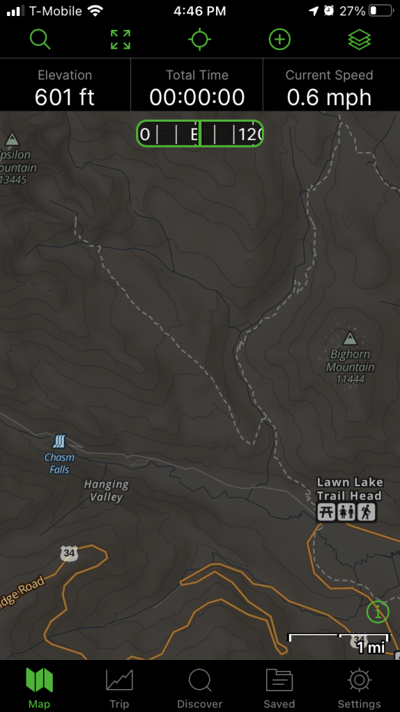
Here is the Lawn Lake trailhead in Rocky Mountain National Park on the Gaia Topo mapSame trailhead (Lawn Lake RMNP) as it appears on the USGS map.
Download Maps
To download a map for off-network use, you simply open the app, click “+” and select “Download Maps.” A rectangle will appear on your screen and you can move the corners to select the area you need downloaded. You will then have an option to name the map and it is saved on your phone.
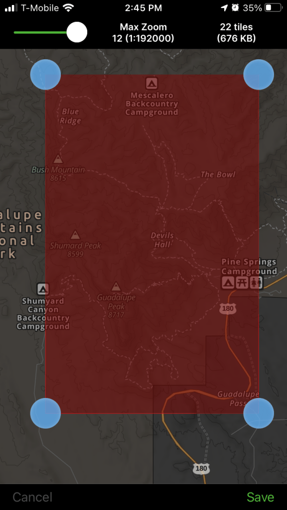
So, for example, if I were planning a trip to the Guadalupe Mountains, I would open the app, move the map to the Guadalupe Mountains, adjust the boundaries of the download area, and save the map:
The four corners of the download are are customizable. This is the area I would choose to climb Guadalupe Peak and a side trip to the Bowl.
Even though the Guadalupes are miles from the nearest cell tower, once hiking I can open the Gaia GPS app and see my location moving on the downloaded topo map. The display also uses the phone’s compass to show you what way you are facing on the map. This makes it almost impossible to get lost.
Download Routes
In addition to downloading maps, you can save routes and waypoints for use when off-network. Routes can be created in the app directly by clicking “+” and selecting “Create Route” then clicking the points on the map. The app automatically connects points along a trail if the two points are on-trail.
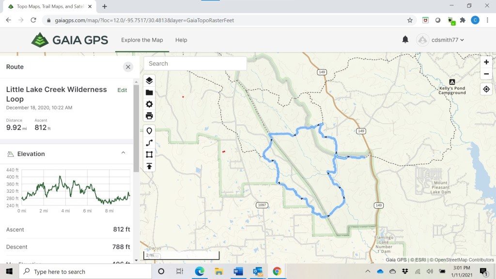
More often, I log in to the Gaia GPS website and create routes on my computer, which are then automatically uploaded to my phone. For example, here is a route I created for a trip to the Little Lake Creek Wilderness in East Texas. The route includes not only distance but an elevation profile:
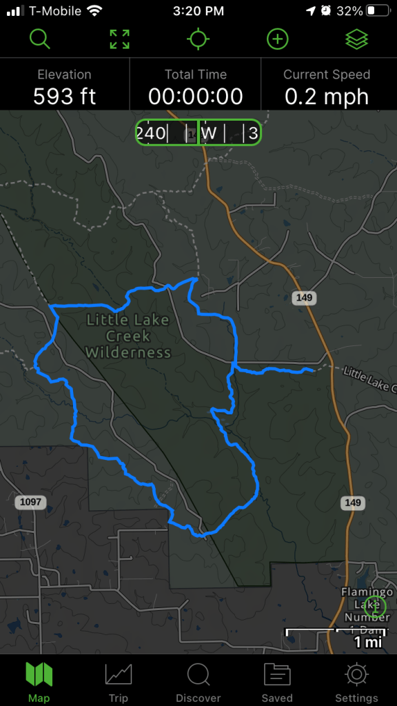
Here is what it looks like on my phone using the Gaia Topo base map:
Or the USGS Topo base map:
Once I am out on the hike, my location will be a visible as an arrow moving on the map.
In addition to creating maps, you can also import routes as GPX files. Many races provide GPX files of the course which can be downloaded from the race website. For instance, when I ran the Run Rabbit Run 100 in 2019, I pre-downloaded the GPX file from the race website into Gaia GPS on my phone so I was always able to confirm that I was on-course.
Download and Create Waypoints
Like saving routes, the app makes it easy to save waypoints, including photographs for documenting a route.
Nice Fort on the Greenbelt – lets me tag my photo to a map.
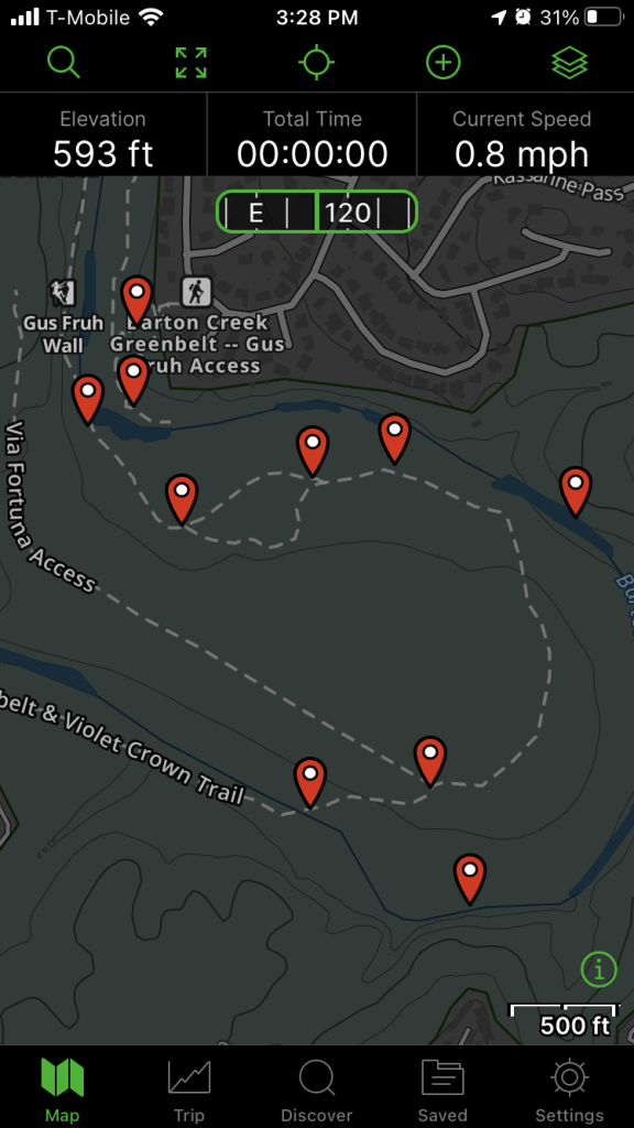
For a Cub Scout orienteering event, I planted flags on the Barton Creek Greenbelt for the scouts to find using traditional map and compass methods. Here is what that looked like on my phone:
The waypoints marked. If you tap on the waypoints, you pull up waypoint lat/long and bearing and distance from current location.
When I got home, I logged into Gaia GPS and created printable maps for the scouts:
Recording Races and Hikes
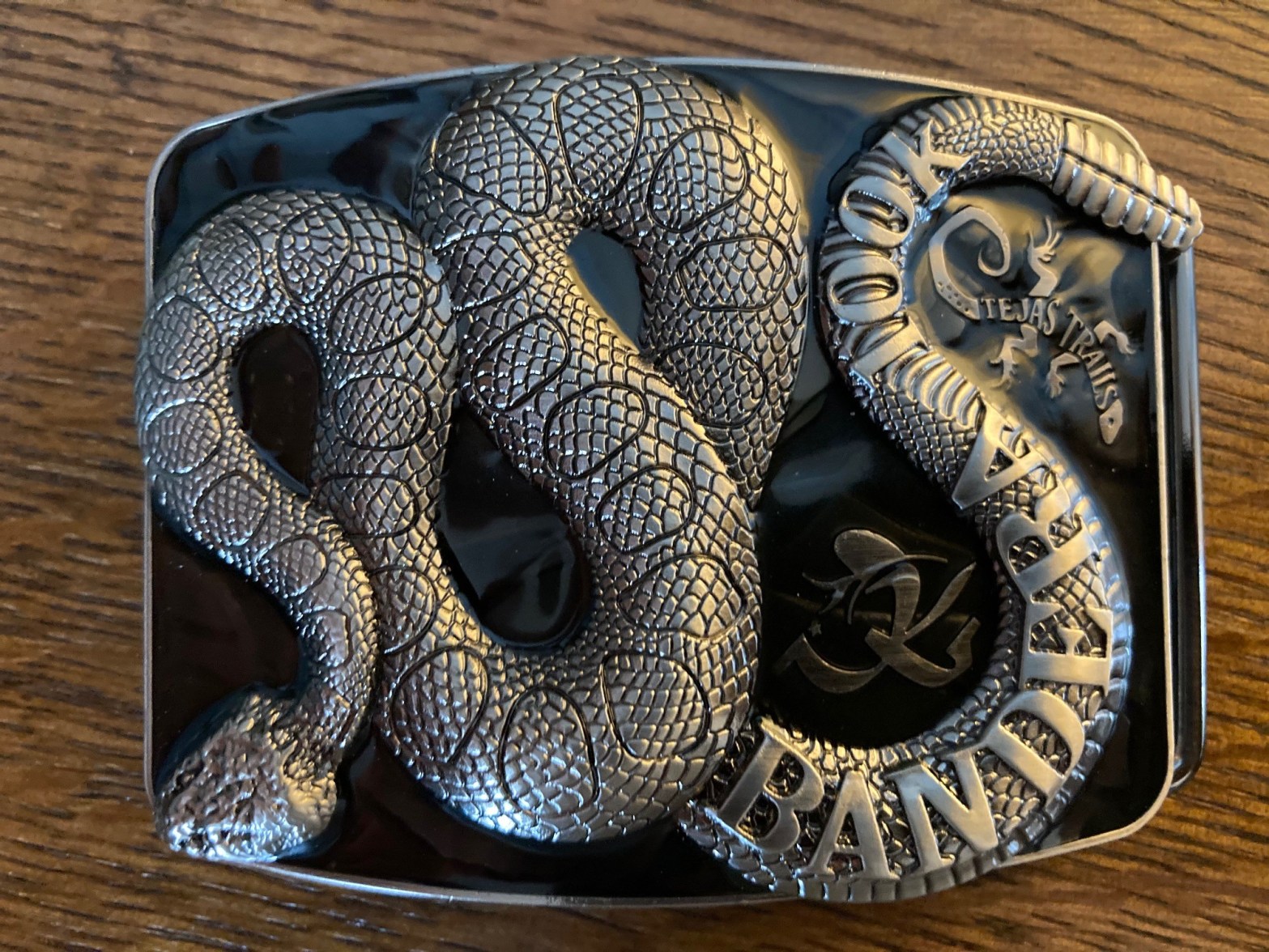
To record a track, I just open the app, select “+” and “Record Track” and the app starts recording. Importantly, it runs in the background and uses very little battery life. For example, when I ran the Bandera 100k, Gaia GPS recorded for over 15 hours. My phone was on airplane and battery saver modes during the event and went from 99% charged to 65% charged.
Bandera 100k track (as seen through the website interface).
I am confident the app can record most ultramarathons with high accuracy on a single battery charge. Once recorded, tracks can be exported as GPX files to fitness platforms like Strava or as KML files to Google Earth.
One thing I have observed is that the vertical ascent and descent calculation in the Gaia GPS app is sometimes lower than other apps, particularly on rough courses. For example, the Gaia GPS app shows my Bandera 100k track with 4,383 feet of ascent. When I exported the GPX file to Strava, Strava shows 6,469 feet of ascent. This is because the algorithm Gaia GPS uses “smooths” the small vertical bumps compared to other algorithms. In any event, it does not affect the utility of the app for navigating or recording tracks because it exports the full GPX file to other apps (which then adjust the vertical data per their own algorithms).
GPS Watch v GPS Phone App?
While I am a big fan of Gaia GPS, I still prefer a GPS watch for some situations – mainly when I need to know my pace in the middle of the event, e.g., tempo runs and races up to marathon distance. For ultramarathons and backpacking trips, I primarily need to know where I am, the elapsed time and, in the mountains, altitude (which is best with a barometric altimeter). I almost never need to know my pace beyond ballpark calculations and most watches don’t have the battery life to provide accurate GPS distance and elevation measurements for most ultramarathons, particularly for a mid-pack competitor like me who is going to be out on the course for a while. Even if there was an affordable GPS watch with a barometric altimeter and with a battery life to accurately record a GPS track for 40+ hours, I would still carry my phone with me anyway for photos and music and would use Gaia GPS for navigating with a big bright phone screen.
Bottom Line
For those of us who spend significant time in areas without cell coverage, having a reliable navigation tool is a matter of safety. For actual functionality and aside from short distance (marathon or less) fast-paced running, its hard to beat this $20 phone app for GPS functions.
This weekend I ran the Hoka One One Bandera 100k with my brother Tim and buddy John. As I mentioned previously, this was a last-minute decision, and I am glad I did it. While it had all the normal suck of an ultramarathon including a short night march, it also was the first time in over a year that I had the chance to compete in a real race. Writeup below and Strava data here.
Let me Start with Kudos to Tejas Trails
In a time where a rational assessment of COVID risks is scarce, the race organizer Tejas Trails managed put on a relatively normal race. There were two main risk management strategies. First, in lieu of a mass start with 400 people, each racer was assigned a starting window and the race was chip timed. On a narrow course like Bandera where an initial conga line and hurried passing are always concerns, the spaced start was a major improvement. The race organizers should continue to use this start approach regardless of COVID.
Second, the aid stations were modified to promote social distancing. These changes included pre-packaging food in individual containers, the use of wands to fill water bottles, and asking volunteers and runners to cover faces when around aid stations. In all, minor inconveniences. There was less sitting around and stopping at aid stations than a normal race (no mass of runners with shoes off in the warming tent) but that is also an improvement.
Was COVID risk zero at the race? No. But with the above adjustments it was minimized, and I suspect that the risks were in line with or less than indoor activities like going to the grocery store.
Other Race Logistics
The race is held at the Hill Country State Natural Area, a little over two hours west of Austin. The course is two 31-mile loops. We picked up our race numbers on Friday night and then headed to our bed and breakfast for dinner. The weather forecast called for an overcast race day with highs in the 50s with possible showers in the evening. Other than the first 5 miles after starting, I ran most of the day in shorts and a t-shirt, and only needed to put on a fleece after dark. I carried a warm hat and Houdini jacked in case, but the rain held off and they stayed in the pack.
On race morning, we arrived just before our 7:00 am start window, picked up our timing chip, dropped a bag in the field by the start, and rolled. We were running within ten minutes of parking.
First light and ready to get after it.
Hydration and Nutrition
Unsure of how functional the aid stations would be, we made the decision to carry all our food and most of our water. I loaded up my Salomon ADV Skin 12 pack with a liter of water in a platypus and two half-liter soft bottles up front. For me, this was enough water for at least 20 miles and I probably could have stretched it to 31. I also carried plenty of salt pills as I had to be prepared to drink only water. I ended up refilling the soft bottles once on the first loop with Tailwind. After realizing that aid stations were fine, I dropped the platypus at the turn and ran the second loop with just two soft bottles and alternated water and Tailwind.
Regrouping after the first 31-mile lap. Note all the space to safely spread out.
For nutrition, I started the first loop with four PBJ sandwiches, two small bags of fritos, and some leftover Halloween candy. Every hour I ate half a sandwich and candy, which worked fine. But even PBJ gets monotonous after a while so on the second lap I relied mostly on aid station food, my favorite being a cup of ramen mixed with instant mashed potatoes.
The Race
Despite having finished in 2015, I had forgotten how flat the Bandera course is. The course is very runnable, with only short climbs breaking up the first half of each loop. The back half of each loop is entirely runnable except for a single short steep climb near the end. Dedicated vertical training is not really required for Bandera. The one variable that changes the nature of the course is mud. In 2015, all the runnable sections were slippery foot-sucking mud. This year, those sections were dry and fast.
Tim moving well up one of the climbs.
Our strategy was to go as fast as we could to be as far along as possible before sunset and to beat any rain that might turn the course muddy. We ended up completing the first 31-mile lap in 6:32. We made it halfway around the second lap before darkness fell and we were reduced to marching it in. The second lap took 8:43, so about two hours of slowdown compared to the first lap. My final time was 15:15, which is 4 hours and 31 minutes faster than in 2015.
Glad to get it done. John finished shortly after.
Final Thoughts
Two months is normally insufficient to train for a 100k. In November I ran about 160 miles, including a couple of runs over 20 miles. But in December the combination of IT band issues, the holidays, and family obligations kept me from training as consistently as I would have liked. Nevertheless, I felt confident at Bandera because I knew I had a good hydration and nutrition strategy and because the weather was good. The strategy to move as fast as possible until dark and then just accept that with the dark my pace would inevitably slowdown was the correct one.
I can’t overemphasize how refreshing it was to get back to racing. We cannot allow our fear of a virus to deprive us of opportunities to grow through challenges. I hope that 2021 brings lots more of those opportunities.
A couple of weeks ago I had a disaster workout. I took a hard fall on the rocks a few miles into a long run, then just muddled through. To describe it as an uninspiring performance would be charitable. As we walked to the car after, I told John that the last three hours had been just going through the motions. When I put the run on Strava Tim in Dallas posted an unprompted comment – “Go through the motions.” The suck level was obvious just from the numbers, but he meant it and I took it as a compliment.
Going through the motions is severely underrated. We are not always going to bring our A Game or feel motivated or be fully prepared for the challenge the day has in store. The choice we then face is:
(a) Do I go through the motions? or
(b) Do I not even go through the motions?
How we answer this question is often the difference between success and failure.
When we choose to go through the motions, we are choosing to be consistent. And consistency is the secret sauce for self-improvement. This is true regardless of what we are trying to improve. Racing, getting strong, building a business, becoming proficient in another language, learning an instrument, improving mental health, staying sober, achieving career goals, being a good parent; all these require consistency.
When I reflect on things I have failed at, the problem is not that I had a bad plan but that I failed to consistently execute the plan. That is the reason I can’t play the guitar or speak Spanish.
The truth is that for most things consistency in executing a plan is more important than the details of the plan itself.
For an example, let me bring it back to running. One thing I have often posited is that anyone who can walk can finish a marathon. (In point of fact, many people who can’t walk finish marathons). When I say this some people get offended or look at me in disbelief. But those people do not understand the power of consistent effort applied over time. The steps to finishing a marathon are simple:
Decide to finish a marathon.
Pick one of the thousands of beginner marathon training plans off the internet. It does not matter which one. They all work.
Do the training plan. Do every workout. Slow is fine. Walking is fine. Go through the motions.
Anyone who does this will finish and will likely find themselves to be a different and improved person at the end. Step 3, the consistent execution, is the hard step.
Its good to be a dreamer, good to set goals, and good to formulate plans for success. But all our dreams, goals, and plans are useless without consistency of execution. We must do. We must act. And sometimes that means we just have to through the motions.
For those without little kids, it may come as a surprise to learn that much has changed when it comes to school choice. With a current 7th grader and 5th grader, among others, I have learned that going to middle school is no longer “just go the middle school.” Instead, students in our district may choose to apply to one of two “magnet” middle schools, another middle school with a “Green Tech Academy,” or, if the student is a girl, a school for “Young Women Leaders” (“Young Men Leaders” are, apparently, out of luck). All these options have put pressure on the regular non-magnet middle schools to up their game and many now have impressive academic programs. For those with the means to send their kids to private school, there are even more choices. All this is great.
But the plethora of choice is not without stress. Among many parents there is an unspoken fear that if my kid is not in the “right” school from a young age, there go the hopes of educational and career success. That type of thinking is nonsense.
The one thing that distinguishes successful people is not smarts, or looks, or innate skill, or where the diploma is from, or certainly not where they went to middle school, but rather whether they can grind. Someone who grinds can set a long-term goal and consistently put in the work to achieve that goal. Grinders develop skills and expertise. Grinding is not checking boxes or putting in face time at the office or being content to be comfortable just because of the money, it is an unrelenting process of improvement. Grinders do not stand still; they are always moving up. People who grind are valued by employers and, after a while, the process of grinding imbues a sense of confidence that allows grinders to choose their own career path. Whether a plumber or a physicist or a pediatrician, grinders have options, and options equals power in the real world.
School needs to be interesting enough and challenging enough to keep students engaged so that they can learn how to grind. For some kids that might be a rigorous academic program with lots of homework. For others it might be a school with good athletic programs where the lessons of practice, teamwork, and winning and losing are learned on the field. For others it may be a school with a great drama teacher who brings out the inner thespian in a shy student who spends many nights staying up late memorizing lines. Point being, there are opportunities to learn the value of hard work at every school provided students push themselves, and parents push their children, to take advantage of those opportunities.
Parents who think a specific school is going to make their kid a success – or not getting into a school will limit success – are missing the picture. It’s up to us to teach our kids how to grind by example, by setting and enforcing expectations, and by helping them discover the interests that bring out their passions. Engaged and supportive parenting that demands accountability is way, way, way more important than any specific school.
There is a lot of pressure when it comes to instilling our children with the tools for success. But that pressure is not getting our kids into the magnet middle school (though if they do and want to go, great). That pressure is on us parents to be involved with our kids’ lives and teach them the value of hard work. After all, raising kids is a grind.